Part VI · Ranging Out
Valley or Ridge? Reading a Topo Map
The Map That Shows the Hills
How do you read a topographic map?
Read the contour lines: each brown line connects points of equal elevation, the marked interval (often 40 feet on standard maps) tells you how much height sits between neighboring lines, and the spacing does the rest: lines packed close mean steep, lines spread wide mean gentle, no lines mean flat. Everything else on a topo map is labeling; the contours are the terrain itself, drawn.
The topo map is the navigation chapter sequence's foundation (compass in Chapter 41, digital in Chapter 42, staying found in Chapter 50), and it comes first on purpose: a compass without map-reading points you accurately toward things you can't identify, and a GPS app without map-reading shows you a blue dot on a picture you can't interpret. Learn contours and both tools become extensions of something you understand.
The learning method that actually works: pull the topo of terrain you already know (your campground, your favorite trail, your town's hill) and read it against memory. The lake you've swum, the climb that winded you, the ridge with the view: seeing known ground translated into lines teaches more in twenty minutes than any diagram, this book's included, though this book's is coming anyway.
Contour lines: the whole trick
Four facts run every contour: the interval (printed in the map margin: "contour interval 40 feet" means each line is 40 vertical feet from its neighbors), index lines (every fifth line, bolder and labeled with its elevation, so you count from them instead of from sea level), spacing = slope (close lines climb hard; the cliff is where lines merge or nearly touch), and lines never cross (they can't; a point has one elevation; apparent crossings are overhangs or map errors, and you'll basically never see one).
The counting skill: to get any point's elevation, find the nearest labeled index line, then count intervals up or down to your point. To get a climb's total gain, count the lines your route crosses going up and multiply by the interval, which is exactly the number Chapter 39's pace formula wants (that "5-mile loop with 1,200 feet" figure came from someone counting 30 contour crossings at 40 feet).
The one-glance skill that grows from it: steepness pattern-matching. A trail that runs parallel to contours is flat; one that crosses them gently, angling, is a sane grade; one that crosses them perpendicular and packed is a stair-climber; and a slope where the lines stack into a dark band is a cliff, whatever the trail's optimism. This single glance, applied at planning time, prevents most of the "the map didn't say it would be like this" genre.
The V rule and reading water
Contours form V and U shapes wherever a slope is creased, and the V rule decodes them: Vs pointing uphill are valleys, draws, and streams (water carves the crease; the V's point aims upstream, toward high ground), Vs or U-shapes pointing downhill are ridges and spurs (the land's nose, aimed at low ground). Find a blue stream line and the surrounding contour Vs will all point upstream across it, which is also how you know which way any drainage flows without a single label.
This rule plus water reading opens up most terrain sense. Streams live in valley creases and gather downhill into rivers (blue lines joining like tree branches, the trunk pointing downstream); lakes sit flat (contours ring their shores); springs and marshes mark where water surfaces (their symbols matter in dry country, Chapter 59). The wet-and-low logic also finds camps: benches above streams (Chapter 30's favorite real estate) appear as wide contour spacing one or two lines above the blue.
Saddles complete the basic vocabulary: the low point on a ridge between two highs, drawn as an hourglass of contours (two sets of rings pinching toward each other). Saddles are where trails cross ridges, where wind funnels (Chapter 30's site read, at map scale), and where passes got their names.
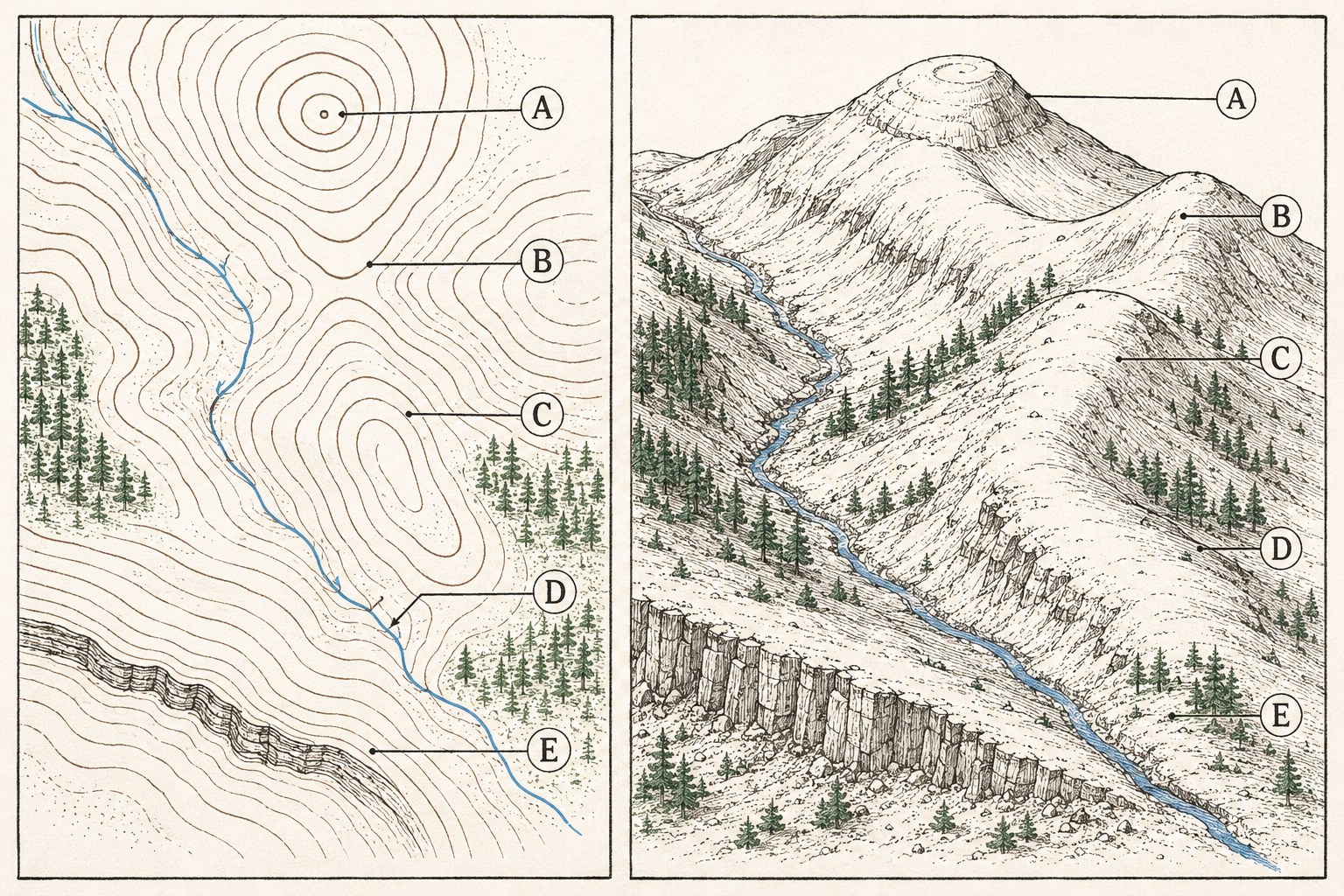
Landforms at a glance
The recognition set, building on the V rule: peaks are closed concentric rings (the innermost ring is the top; a tiny circle with an X or elevation label is the summit); ridges are elongated downhill-pointing Us, often connecting peaks (walkable high routes, and the terrain feature most visible in real life); valleys and draws are the uphill-pointing Vs (travel corridors, water, and cold-air pools per Chapter 30); spurs are small ridges running off big ones (the classic wrong-turn feature: descending the wrong spur is how people leave a summit toward the wrong drainage, a Chapter 50 case study); bowls and cirques are C-shaped ring stacks open on one side; depressions (rare) are rings with inward tick marks, the map's way of saying "this hole is real."
The skill that assembles them: pick any point on the map and narrate its view. "Standing here, the ground rises to the northeast toward that peak, drops left into the creek's draw, and the ridge behind me runs south to a saddle." When you can talk terrain from lines, you can also run the trick in reverse (looking at real hills and finding yourself on the map), which is the entire foundation of staying found, and it's a genuinely pleasant campground-chair hobby besides.
Scale, distance, and the paper you want
The standard American hiking map is the USGS 7.5-minute quadrangle at 1:24,000 scale: one map inch equals 2,000 feet on the ground, a scale detailed enough to show individual gullies and buildings. Recreation maps (the popular branded trail maps) commonly run 1:40,000–1:75,000: less detail, more coverage, better for trip planning, worse for fine navigation. Know which you're holding; the same thumb-width is a quarter mile on one and a mile on the other.
Distance measuring, field-grade: the map's scale bar plus anything straight (a pine needle, the compass edge, a marked string for the fastidious) measures straight-line distance, and trail distance runs longer, often much longer in switchback country. The honest trick: measure the straight line, then add by terrain (flattish trail +10–20%, switchbacked climbs +50% or more), or count the trail's actual wiggles at the scale where they show. Digital tools (Chapter 42) measure routes exactly, which is one of their genuine superiorities; the paper skill remains the backup and the sanity check.
Where to get maps: USGS quads are free as PDFs (printable at home in sections), FSTopo covers the forests, and the print-on-demand and custom-center services (CalTopo and its kin) build exactly the map your trip needs. The Chapter 12 rule stands regardless of source: paper rides along, in a zip bag, because it needs no battery and survives swims badly but better than phones.
Symbols and colors: the labeling layer
The color code is stable across American topo maps: brown contours, blue water (solid = year-round, dashed = intermittent, the distinction that matters enormously in September per Chapter 17), green vegetation dense enough to notice, white open ground (meadow, rock, alpine; white doesn't mean flat, it means unforested), black human things (trails as dashed lines, buildings, boundaries), red major roads and survey lines, and purple on older quads for revisions.
The symbols worth memorizing are few: trail (dashed black), road grades (double lines down to jeep-track dashes, which Chapter 28's dirt-road judgment reads before driving), buildings and ruins (squares; the labeled ruin is a landmark gift), springs (blue circle-with-tail, gold in dry country), mines and caves (the pick-and-crossed-hammers and the Y, both meaning "interesting" and "don't"), power lines (the dot-dash line kids mistake for trails), and the marsh tufts that explain why the flat "shortcut" ate a boot.
Everything else lives in the legend, and the legend habit is the actual skill: two minutes with a new map's margin (interval, scale, date, declination note for Chapter 41) before trusting it. Map dates matter more than people expect: trails move, roads close, and a 1980s quad's "trail" may be an alder thicket now, which the recent-report habit from Chapter 3 cross-checks.
Orienting the map and planning routes
A map speaks clearest oriented: rotate it until its features align with the world (the lake northeast on paper sits northeast in reality), which you can do by eye against two known features, or precisely with the compass (Chapter 41's first job). An oriented map turns every visible landmark into a labeled signpost, and the habit of re-orienting at every stop is half of never getting lost (Chapter 50 formalizes the other half).
Route planning with contours is Chapter 39's math with eyes: trace the candidate route, count crossings for total gain, glance the steepness patterns for the hard sections and the cliff-band no-gos, note the water (fills and dry stretches, Chapter 17), and mark the handrails and catch points (the stream the route follows, the road that catches you if you overshoot; Chapter 50 will name these formally). Ten minutes over the map at the picnic table converts tomorrow's hike from a guess into a plan with mile markers.
The last habit is the naturalist's: after the hike, revisit the map and match what you walked to what was drawn. The saddle that surprised you, the switchbacks the map compressed: each reconciliation upgrades your translation skill, and after a season of it you'll read contour country the way you read street maps, instantly and without noticing the work.
Trailhead Takeaways
- Contours are the terrain: interval from the margin, count from index lines, close = steep, stacked = cliff.
- The V rule: Vs point uphill in valleys and upstream across creeks; Us point downhill on ridges. Water gathers like branches toward the trunk.
- Vocabulary at a glance: rings = peak, hourglass = saddle, C-stack = bowl, small ridge off big = spur (the wrong-turn feature).
- 1:24,000 quads for navigating, coarser recreation maps for planning. Straight-line distance plus 10–50% for the trail's honesty.
- Colors: brown terrain, blue water (dashed = seasonal), green forest, white open-not-flat, black human, dashed black trail.
- Read the legend, the date, and the declination note before trusting any map.
- Orient the map to the world at every stop; count contour crossings before promising anyone an "easy five miles."
Where Trips Go Sideways
- The mileage map-glance. The route looked short and nobody read the brown lines packed under it. Chapter 39's death march was planned right here, at the picnic table, in the ten seconds the contours weren't consulted.
- Wrong V, wrong valley. The draw and the spur read identically to the hiker who never learned the pointing rule, and the descent followed a V the wrong way into the wrong drainage. One rule, two minutes to learn, and it was the difference.
- The 1:75,000 confidence. A thumb-width looked like a stroll on the planning map and unfolded into four real miles. Know the scale before the thumb does the estimating.
- Dashed blue in September. The route's water plan hung on a creek whose map line was dashed, which is the map saying "seasonal" in its quiet voice. Solid blue plans; dashed blue hopes; recent reports decide.
- The 1987 trail. On the map, a clean dashed line; on the ground, alder and regret. Map dates are printed in the margin for exactly this reason, and current apps or reports adjudicate every old quad's promises.
Frequently asked
What do the lines on a topographic map mean?
Each brown contour line traces a single elevation; the printed interval (often 40 feet) is the vertical gap between neighbors. Spacing reads as slope: wide apart is gentle, packed tight is steep, merged into a band is cliff. Bold index lines carry elevation labels so you can count from them.
How do you tell a valley from a ridge on a map?
The V rule: contour Vs pointing uphill (and upstream across any blue line) are valleys and draws; Us or Vs pointing downhill are ridges and spurs. Check against water when present, since streams always occupy valley creases and the Vs around them point toward their source.
What is the best topographic map scale for hiking?
1:24,000 (the USGS 7.5-minute quad standard): one inch equals 2,000 feet, enough detail for gullies, springs, and fine route choices. Coarser 1:40,000–1:75,000 recreation maps plan trips well and navigate poorly. Carry the detailed one for the ground you'll actually walk.
What do the colors on a topo map mean?
Brown for contours, blue for water (solid perennial, dashed seasonal), green for forest, white for open ground (unforested, not necessarily flat), black for human features including dashed trails, red for major roads. The legend and the map's date live in the margin and both deserve a look before you trust anything, because trails move and creeks go seasonal faster than quads get revised.