Part VI · Ranging Out
What Clouds Mean a Storm Is Coming
Sky Signs
How do you read clouds to predict weather?
Read the trend, not the snapshot: skies that are thickening and lowering are deteriorating (a front is coming, usually with half a day's warning or more), skies that are lifting and breaking are improving, and puffy fair-weather clouds that start towering upward before noon promise afternoon thunderstorms. Those three trends, plus the cloud names to track them with, are the entire useful core of camp weather reading.
Why learn this in the forecast-app era: apps forecast regions and hours; the sky over your campsite forecasts here and soon, updates continuously, and works with no signal, which is most campsites. Chapter 4 taught reading the professional forecast before the trip; this chapter is the field update service that runs all weekend, and it pairs with Chapter 44 the way smoke detectors pair with extinguishers: this one warns, that one responds.
The observation habit that makes it work costs nothing: a deliberate sky check at morning coffee and again at dinner, noting what's there and, critically, what changed since last look. Weather reading is differential; single glances read mood, comparisons read intent.
The four families, sorted by height and shape
All cloud names combine four Latin roots: cirrus (wisp: high, icy, feathery), cumulus (heap: puffy, flat-bottomed, vertical), stratus (layer: featureless sheets), and nimbus (rain-bearing, as prefix or suffix). Height sorts the families: high clouds (cirrus family, above ~20,000 feet: ice wisps, halos, no rain themselves, but messengers), middle (alto- prefix: altocumulus, altostratus), and low (stratus, stratocumulus, fog, plus nimbostratus delivering the steady rain), with cumulus and its storm-king cumulonimbus spanning levels by growing.
Height-guessing from the ground has one honest trick: high clouds never blur the sun's edge (ice wisps; you'll see halos), middle clouds dim it to a bright patch, low clouds erase it. And the two names worth pronouncing correctly at the fire because they matter most: nimbostratus (the low gray blanket that rains steadily for hours; boring, wet, safe) and cumulonimbus (the anvil-topped tower that delivers lightning, hail, and Chapter 44's entire agenda; dramatic, dangerous, watched).
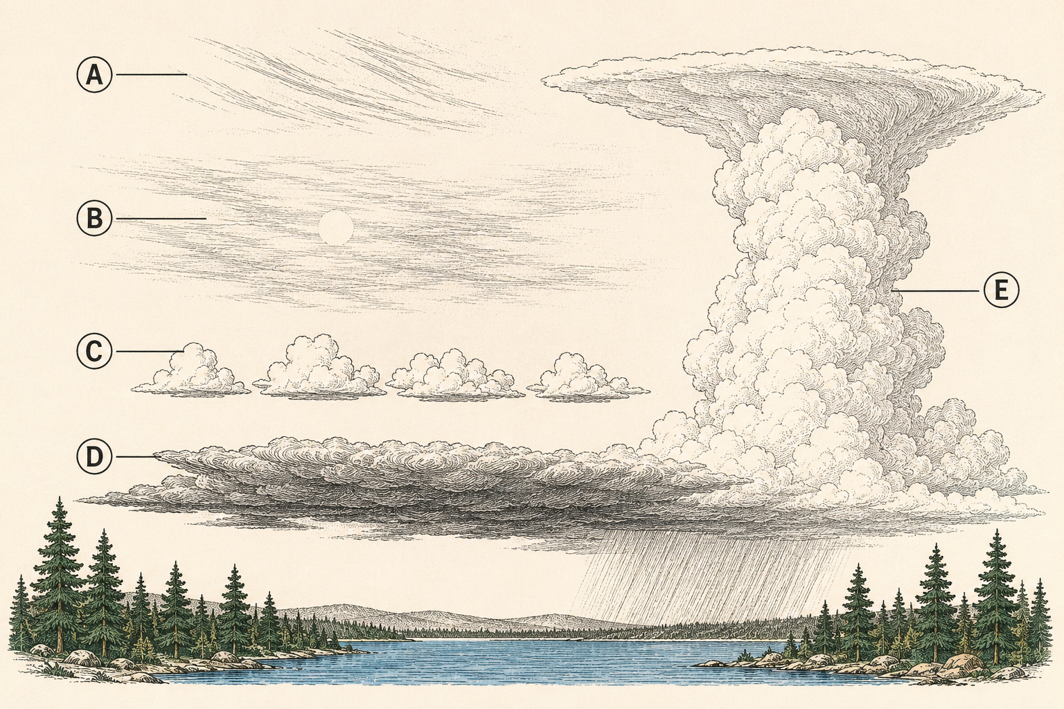
The deterioration sequence: a front, announced
Warm fronts telegraph their arrival in a sequence readable 12–24 hours out, and it's the single most useful pattern in the chapter: cirrus wisps appear in a clear sky (change is coming, timing unknown), thicken into a cirrostratus veil (the milky sheet that puts a halo around sun or moon: precipitation likely within a day), lower and darken into altostratus (sun reduced to a dim patch: rain likely within hours), and finally arrive as nimbostratus (the blanket; the rain is here, and it's the steady multi-hour kind).
Camp translation at each stage: at cirrus, note it and check again in three hours (trend, not snapshot); at the halo, tomorrow's plans get weather-proofed (the tarp goes up tonight per Chapter 8, gear gets staged dry per Chapter 31); at the dim-sun stage, today's plans compress (the far hike becomes the near one, per Chapter 4's window logic); at the blanket, you're living Chapter 31's rain camp, hopefully smugly, because the sky gave you a day's notice and you spent it.
Cold fronts run faster and rougher: a building wall of cumulus and cumulonimbus, often on a wind shift, with hours of warning instead of a day, squally violence instead of steady rain, and dramatic clearing behind. The sky look is different (towers, not veils) and the response is Chapter 44's, not the tarp's.
Cumulus day rules: the summer forecast
Fair-weather cumulus (the flat-bottomed sheep) are stable air's signature and a fine forecast all by themselves: if they stay small and flat through midday, the afternoon stays friendly. The rule that matters is their vertical ambition: cumulus towering by late morning means thunderstorms by afternoon, and the earlier the towering starts, the earlier and harder the storms. Chapter 4's mountain pattern (hike early, off ridges by early afternoon) is this rule pre-applied; the sky check at breakfast is what confirms or relaxes it on any given day.
The escalation ladder to watch: cumulus congestus (cauliflower towers taller than wide, crisp edges) is the yellow light; cumulonimbus (the tower goes anvil-flat on top, base darkens, virga or rain shafts visible) is the red one, and distance is deceptive because storms travel and build downwind of themselves. The rough range gauge: lightning's flash-to-thunder count divided by five gives miles, and Chapter 44 takes over well before the count gets small.
Two summer specials complete the set: altocumulus castellanus in the morning (mid-level clouds sprouting little turrets, like battlements) is the classic "storms today, count on it" sign that mountain veterans act on at breakfast; and towering clouds over ridges while valleys stay clear mark where the day's convection is anchored, which is route information as much as scenery.
Local winds and pressure: the feel of change
Terrain breathes on a schedule (Chapter 30 used it for camp placement): valley breezes run upslope through warm afternoons and downslope after sunset, lake shores run onshore by day and offshore by night, and the schedule's interruption is the forecast: a wind that shifts direction against the local pattern, strengthens oddly, or goes dead calm and heavy usually means a system is overriding the local machinery. The classic pre-thunderstorm signature is exactly that: the day's breeze dies, the air goes still and expectant, then the gust front arrives cold and hard from the storm's direction.
Pressure is the physics under all of it, and campers now carry barometers (most smartwatches and many phones): a steady fall over hours confirms what thickening clouds suggest, a fast fall sharpens the warning, a rise backs the clearing trend. No numbers needed beyond the arrow's direction; the app's pressure graph read at the two daily sky checks adds instrument confirmation to eyeball trend-reading.
Smoke completes the camp instrument set: campfire smoke rising straight says high pressure and settled air; smoke that flattens and hangs low says the air is heavy and often pre-frontal (pressure falling, inversion forming). It's a real signal with real physics, unlike most of its folklore neighbors, which get their grading next.
Folk signs, graded honestly
"Red sky at night, sailors' delight; red sky in morning, sailors take warning": B+. Real physics in the mid-latitudes where weather moves west to east: evening red means clear air west (tomorrow's weather), morning red means the clear air already passed and something's behind it. Works often; trust it as a trend input, not a verdict.
Halo around the sun or moon: A. That's cirrostratus, the deterioration sequence's second act, and the most reliable folk sign there is: precipitation follows within a day more often than not.
Cricket chirps as thermometer: A for charm, real for temperature. Count chirps in 14 seconds and add 40 for a rough Fahrenheit reading (snowy tree crickets keep this bargain best). It forecasts nothing, and it's the best campfire party trick in this book.
Heavy dew or frost at dawn: B. Clear, calm nights produce dew and settled mornings; its absence on a warm, windy dawn hints at incoming weather. Indirect and decent.
"Rain before seven, done by eleven," rings around anything else, aching knees: C and below. Occasionally right, mechanism thin, entertainment value only. The sky's actual sequence out-forecasts all of them, which is why it got the chapter.
Wind chill and what "feels like" means
Wind chill is the honest accounting of wind's theft: moving air strips the warm boundary layer off skin, making heat leave faster, so exposed skin at 40°F in a 20 mph wind loses heat like a much colder calm day (the "feels like" number in every app). It changes no thermometer readings and every human ones, which is why Chapter 4 read wind before temperature and Chapter 23's shell is the off-switch.
Camp use is straightforward: the feels-like number, not the air temperature, picks the layers and sets the kid rules (Chapter 51's cold thresholds run on it), exposed skin gets covered when feels-like drops toward the teens (frostbite math starts caring, Chapter 49), and wind chill's warm-season cousin gets equal respect: wet plus windy at 50°F is Chapter 23's hypothermia weather precisely because evaporation plus wind-strip run together.
The heat mirror, for symmetry: humidity's "feels like" (heat index) means sweat can't evaporate, the body's cooling fails at lower temperatures than the thermometer admits, and Chapter 49's heat section governs. Both indexes exist because bare temperature is a liar in moving air and wet air; the camp habit is simply reading the honest number.
The camp forecast routine
The whole chapter compresses into a two-minute ritual run twice daily. Morning coffee check: what's the sky (families, heights), what's the trend since last night, any towers building or turrets sprouting, what's the wind doing against the local schedule, pressure arrow if you carry one. Set the day's plan and its bail triggers accordingly (Chapter 4's windows, Chapter 44's thresholds). Dinner check: same questions, plus tonight's implications: tarp tension, guyline audit (Chapter 31), fire plans against wind (Chapter 33), and anything that shouldn't sleep outside.
Add the passive layer: notice the sequence markers whenever you're moving (halo at lunch means the dinner check matters more), and log the hits and misses casually, because calibration to your region is real: coastal, mountain, desert, and plains skies each have local accents, and a season of paying attention teaches yours.
The routine's real product is the same as the site-read's in Chapter 30: decisions made early and calmly instead of late and wet. Weather reading doesn't prevent weather; it converts surprises into appointments.
Trailhead Takeaways
- Read trend, not snapshot: thickening and lowering deteriorates, lifting and breaking improves, towering by noon means afternoon storms.
- Four roots name everything: cirrus wisp, cumulus heap, stratus layer, nimbus rain. Nimbostratus bores; cumulonimbus bites.
- The warm-front sequence gives a day's notice: wisps, halo veil, dim-sun gray, rain blanket. Spend the notice on the tarp.
- Morning turrets (castellanus) and early towers move the mountain schedule earlier. Flash-to-thunder over five is miles.
- Wind against the local schedule, falling pressure, flattening smoke: the instruments you already have agree with the clouds.
- Halo: trust it. Red sky: lean on it. Crickets: chirps in 14 seconds plus 40 is the temperature and the party trick.
- Feels-like is the honest number: wind chill for layers and skin rules, heat index for Chapter 49's thresholds.
- Two minutes at coffee, two at dinner. Surprises become appointments.
Where Trips Go Sideways
- The snapshot reading. "Some high clouds, no big deal" was true at breakfast and beside the point: they were new, and by dinner the halo was up and nobody had rigged the tarp. Single glances read mood. Comparisons read intent.
- Ignoring the morning turrets. Altocumulus castellanus at 8 a.m., a summit bid launched at 10 anyway, and the party met the afternoon on an exposed ridge exactly on the schedule the sky had published. The battlements were the forecast.
- The still-air all-clear. The breeze died and the air went heavy, which got read as "nice, the wind stopped" instead of the storm's held breath. The gust front made the correction fifteen minutes later, through camp.
- Thermometer dressing. Forty degrees read as "light jacket" while the 25 mph wind ran the real number into the teens, and the overlook lunch lasted four shivering minutes. Feels-like picks the layers. The shell was in the pack the whole time.
- Trusting the knee. The joint forecast rain; the sky forecast nothing; the group canceled the day for a front that never existed. Grade the folk signs honestly and let the sequence outvote the anatomy.
Frequently asked
What are the 4 types of clouds?
The four root families: cirrus (high, icy wisps), cumulus (puffy heaps), stratus (flat layers), and nimbus (rain-bearing, appearing in combinations like nimbostratus and cumulonimbus). Every named cloud combines these roots with height prefixes; the trends between them, thickening-lowering versus lifting-breaking, are the actual forecast.
How can you tell if clouds are high or low?
By the sun's edge: high ice clouds leave it sharp and often ringed with a halo; middle clouds dim it to a bright smear; low clouds erase it entirely. Texture helps too: wisps and veils ride high, defined puffs and gray blankets ride low, and towers span levels by growing.
What clouds mean a storm is coming?
Two different warnings: the slow one is the thickening sequence (cirrus to halo veil to dim gray) announcing steady frontal rain up to a day out; the fast one is cumulus towering into an anvil-topped cumulonimbus, promising thunderstorms within hours. Morning turret clouds (castellanus) are the day-of storm alarm mountain campers act on at breakfast, usually by moving the whole plan two hours earlier.
How accurate is the wind chill number?
Accurate for what it measures: the rate exposed skin and bodies lose heat in moving air, which is what comfort and frostbite actually respond to. It doesn't change air temperature, so gear and water don't freeze faster; you dress, cover skin, and set kid limits by the feels-like number, not the thermometer's.